1968
Lithostratigraphic subdivision of Post-Hercynian deposits in the South-Central Pyrenees, Spain
Publication
Publication
Leidse Geologische Mededelingen , Volume 41 - Issue 1 p. 221- 228
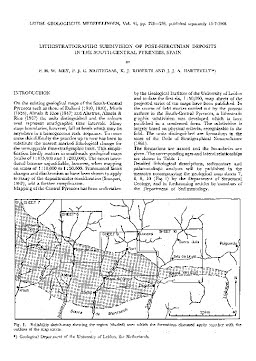
On the existing geological maps of the South-Central Pyrenees such as those of Dalloni (1910, 1930), Misch (1934), Almela & Rios (1947) and Alastrue, Almela & Rios (1957) the units distinguished and the colours used represent stratigraphie time intervals. Many stage boundaries, however, fall at levels which may lie anywhere in a homogeneous rock sequence. To overcome this difficulty the practice up to now has been to substitute the nearest marked lithological change for the unmappable time-stratigraphic limit. This simplification hardly matters in small-scale geological maps (scales of 1 : 175,000 and 1 : 200,000). The errors introduced become unjustifiable, however, when mapping on scales of 1 : 10,000 to 1 : 50,000. Pronounced facies changes and diachronism as have been shown to apply to many of the deposits under consideration (Souquet, 1967), add a further complication. Mapping of the Central Pyrenees has been undertaken by the Geological Institute of the University of Leiden and to date the first six, 1 : 50,000, map sheets of the projected series of ten maps have been published. In the course of field studies carried out by the present authors in the South-Central Pyrenees, a lithostratigraphic subdivision was developed which is here published in a condensed form. The subdivision is largely based on physical criteria, recognizable in the field. The units distinguished are formations in the sense of the Code of Stratigraphical Nomenclature (1961).
| Additional Metadata | |
|---|---|
| Leidse Geologische Mededelingen | |
| Released under the CC-BY 4.0 ("Attribution") License | |
| Organisation | Naturalis journals & series |
|
Mey, P. H. W., Nagtegaal, P., Roberti, K. J., & Hartevelt, J. J. A. (1968). Lithostratigraphic subdivision of Post-Hercynian deposits in the South-Central Pyrenees, Spain. Leidse Geologische Mededelingen, 41(1), 221–228. |
|